Create a free profile to get unlimited access to exclusive videos, sweepstakes, and more!
Was young Mars warm and wet or cold and frozen?

Mars is cold and dry, with a thin atmosphere not even 1% as dense as ours.
Now, that is. The question is, what was it like around 3 billion years ago? Evidence abounds on the surface that plenty of water existed there back then, which also means it had a thicker atmosphere and was warmer, too.
However, a new paper has come out questioning that interpretation of the evidence. Instead of it being warm and wet, the scientists argue, instead it was cold and, well, not dry exactly, but frozen. This is hardly the semi-tropical Earth-like planet that for the past decade or two has been the growing consensus.
In this new work, they looked at the valley networks, systems of interconnected tributaries that have been carved into the surface of Mars, mostly in the southern hemisphere and equatorial regions. On first glance, they look very much like river valleys on Earth, carved by flowing water that’s fed by either rain or a process called groundwater sapping, erosion from water that originally bubbles up from underground like in a spring or seeps out of rocks and sediment.
That conclusion would support a warm, wet early Mars with a thicker atmosphere. However, the scientists in the new research note that this is a conclusion drawn by looking at individual tributaries, and not the overall network they form as the run together. These valley networks can give a more global view that’s worth investigating.
What they did to check this out is clever. They note that erosion like this can come from four major sources: Rivers and sapping (as noted above), and also from glaciers melting from above as well as glaciers melting from below. This last is called basal melting (basal means bottom surface), and can occur when glaciers move across rock, the friction from the shear force melting them.
Each of those forces produces different kinds of erosive channels, with different structures in them. Six of these features — including the angle a tributary meets up with a main channel, the length of a channel versus its width, and how the bed undulates, that is, moves up and down (which relates to things like how fast the water was moving when it carved the channel) — have measurable quantities that can be used to examine Martian tributaries.
On board NASA’s Mars Reconnaissance Orbiter is an instrument called MOLA, or Mars Orbiter Laser Altimeter, which measures the ground elevation beneath it, making a topographical map of Mars. The scientists looked at 66 different valley networks that were made up of over 10,000 tributaries in total (out of over 50,000 MOLA measured), and used a statistical method to examine them for the six features. This was then used to assign an origin source for each network.
What they found is startling. Out of the 66, their analysis found that 22 valley networks were carved by subglacial flow, 9 by glacial erosion, 3 from sapping, and 14 from rivers. 18 networks had an indistinct set of features, and so were not categorized.
So 31 of these valley networks were carved by glacial water flow, and only 17 from surface water! And the ones caused by river flow were localized in one area (called Arabia Terra), whereas the glaciated valleys were widespread.
That’s not at all what the warm wet Mars theory would predict. It’s far more consistent with Mars being very cold at that time. Mind you they did find both types of erosion, so it’s possible it was mostly glaciated with some spots open to the surface. But this is definitely opposed to the going idea of a clement Martian climate back then.
They also point out that some climate models of early Mars around that time (3.5–2.9 billion years ago) indicate the surface should have been cold, and heavily glaciated.
I find this fascinating. Until we started putting high-resolution cameras in orbit and landers on the ground, the idea was that Mars was always dead. Then about 40 years ago that all changed when the surface showed clear indications of water flow. That was a huge paradigm shift for scientists. If this new research is correct, then we’re facing another one.
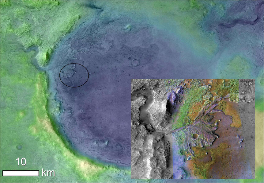
More observations from the ground should be useful; an overview is great but it helps to have in situ measurements as well (there’s a reason we have the phrase “ground truth”). Curious, I checked the maps they used of tributaries, and the ones in Jezero Crater on Mars weren’t included, which is too bad: That’s the target for Perseverance, which will land there in February 2021. There are clear inflow and outflow channels in the crater rim, a fluvial delta where sediment washed in, and evidence of clay deposits (which imply standing water) as well. Still, with the rover there a lot more will be revealed about conditions in the crater when it was a lake.
There’s also evidence of standing water on Mars, including lakes and even what might be an ocean shoreline — the northern hemisphere is in general lower elevation than the south, and may have been a huge global ocean. It’s not clear.
It’ll be interesting to see all this opposing evidence integrated together to see what’s what. Whether Mars was warm or cold, wet or frozen, it’s changed a lot in the past few eons. Why? What happened to it? We’ve got an idea — its internal magnetic field died, and it lost its protection against the solar wind which eroded away its atmosphere, leaving it dry and cold and dead — but the details are still being investigated.
Was ancient Mars blue, or was it white? Hopefully soon we’ll know.


