Create a free profile to get unlimited access to exclusive videos, sweepstakes, and more!
Desktop Project Part 23: What are the odds of a satellite re-entering over water?

[I'm approaching the Desktop Project endgame here; I'm almost out of pictures to post. I've done this every day for weeks, and my computer desktop is almost clean! Of course, more stuff keeps coming in, so I could do this forever. But that would be cheating. Sweet, sweet cheating.]
I've got something different for you today. Over the past few weeks I've posted an illustration, and a couple of dozen pictures, but no graphs! That'll change now, and I think this particular set of plots is nifty.
Whenever a big satellite is about to re-enter Earth's atmosphere -- like UARS, or ROSAT, or Phobos-Grunt -- the media freak out. You start seeing numbers being thrown about of the odds of getting hit by a chunk of flaming debris, and I get lots of panicked email and tweets. Then I have to point out to people that the Earth has a lot of real estate for a satellite to come down on, and of that, 3/4 is water. And most of that is Pacific Ocean. So really, the most likely scenario is a re-entry into the Pacific, or some other ocean, and that's that.
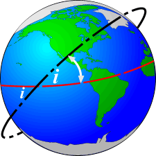
But is that really true? After all, satellites can have different orbits, inclined with respect to the Earth's equator. So the odds of getting dumped in the ocean might be different for a satellite that's over the equator versus one in a polar orbit (that is, orbits almost completely in a north/south direction).
Happily, orbital debris specialist Mark Matney did the math! In a paper published in the Orbital Debris Quarterly Newsletter (bet you didn't know that existed!) he calculated those odds. He created two graphs for the paper, and both are really cool if you're a graph nerd like I am. Here's the first one:
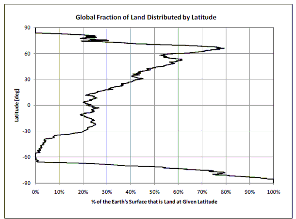
That plot shows the fraction of the total area of the Earth covered by land versus latitude. It's easy to read: at 0° latitude -- the equator -- the amount of land is 23%. In other words, if you flew a plane around the world at the equator, you'd be over land 23% of the time.
I live in Boulder, which is at 40° north latitude, and at that latitude there is a lot more land, about 45%. The big peak at +60° is due to Canada and Russia. Now look at +90°, the north pole. There's no land at all! That makes sense; the north pole is covered by the sea, and the only solid surface is ice, which doesn't count.
Now look at -90°, the south pole: it's 100% land! That too makes sense, since Antarctica is a continent. Even at -85° or so you're entirely over Antarctica.
That graph is totally cool. And armed with that, and some orbital physics (including the fact that the Earth rotates under a satellite as it orbits), Mark was able to calculate how long a satellite spends over land depending on how tilty its orbit is. He came up with this graph:
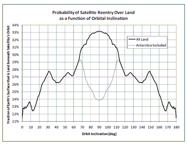
This plots how long a satellite spends over land as a fraction of its orbit, versus the inclination of that orbit -— 0° if it stays over the equator, and 90° if it's on a perfect north/south path.
Check the axis on the left: no matter what the tilt of an orbit, a satellite spends about 22 - 33% of its time over land! The big maximum in the middle is for polar orbits, but that's heavily weighted by Antarctica. Since almost no one lives there, it doesn't really count. That's why he subtracted it (dashed line) in the plot, to give you a better idea of how much time a satellite spends over inhabitable land.
The bottom line: saying the chance of a satellite dropping in the ocean is about 75% is actually pretty close to being right! And remember, people occupy a very teeny percentage of the planet's land area. That's why you've never heard of anyone getting killed by falling satellite debris, and it's actually not even very common to have photos of one coming back down! They tend to fall far from where people are, due to the sheer amount of empty land on Earth.
Disney might think it's a small world after all, but 500,000,000 square kilometers (200 million square miles) is actually a whole lot of room, even when the sky is falling.
Tip o' the deflector shield to PhG_Reentry. Orbit diagram from the Canadian Space Agency.
